Ukrainian child performer finds safety at Sarasota …
Ukrainian child performer finds safety at Sarasota show
Ukrainian child performer finds safety at Sarasota show
Ukrainian child performer finds safety at Sarasota show


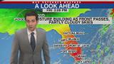
A cold front is expected to push through Friday afternoon and with it bringing subtle changes to the Suncoast. Moisture is elevated ahead of the front and dewpoints are running in the low 70s. Cloud cover will be abundant in the morning just before the front passes.
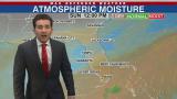
With moisture building ahead of a weak cold front, Thursday starts off on the milder side, with dewpoints in the low 60s. Rain chances will be on the increase today, around a 30% chance. Isolated showers and storms are possible throughout the day, however, the best chance appears later on this evening and into the overnight.

Fair skies and mid-upper 50s across the Suncoast Wednesday morning. Increasing cloud cover will turn mostly sunny skies will turn into mostly cloudy skies by the early afternoon.


A weak cold front pushed through the Suncoast yesterday, dropping temperatures into the mid-upper 50s for Monday morning. Breezy conditions and gusty winds up to 25 mph can be expected throughout the day and a small craft advisory is in effect until 1 pm on Monday.

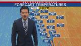
Temperatures this morning across the Suncoast are running in the upper 40s to low 50s, a chilly start to the day. With plenty of sunshine in Friday's forecast, temperatures will be heating up quite a bit into the mid-70s for the high of the day.

A cold front will pass through the Suncoast Thursday morning and with it bringing a chilly evening ahead of Friday. Ahead of the front, a 10% chance for a passing stray shower is possible towards coastal area.
Partly cloudy skies to start off Wednesday morning. Temperatures will trend on the chillier side this morning, running in the mid-50s, before mostly sunny skies dominate and raise temperatures into the low 70s for high of the day.

With slightly cooler-drier air aloft, Tuesday morning on the Suncoast starts off with temperatures running in the 50s and overcast skies. A brief break in cloud clover will see a mix of sun and clouds before more clouds build and make for mostly cloudy skies later on in the afternoon.
